From the ground, we are used to seeing clouds as puffy balls, wispy bands, or long streaks. But they also form other distinct shapes—some of which are only visible from space.
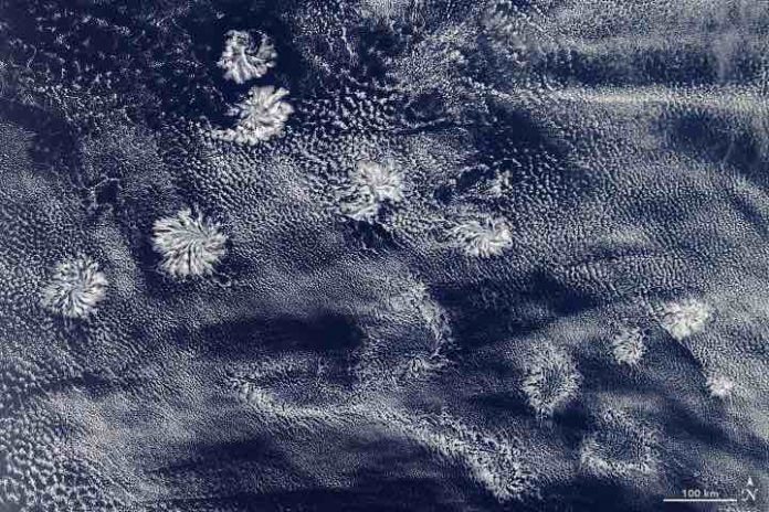
The image above shows a class of clouds known as actinoform. Derived from the Greek word meaning “ray,” an actinoform cloud is a collection of shallow clouds that organize themselves in a distinct, radial structure. Sometimes the cloud system appears with a leaf-like structure or in a spokes-on-a-wheel pattern, as in the image above, with radiating arms called actiniae.
“Actinoform clouds take slightly different forms, but the general structure is consistent,” said Michael Garay, a cloud researcher at NASA’s Jet Propulsion Laboratory.
Actinoform clouds will sometimes appear in lines, but in this case they appear more randomly distributed through the cloud field. The image was acquired off the western coast of Australia by the Moderate Resolution Imaging Spectroradiometer (MODIS) on NASA’s Aqua satellite on January 29, 2020.
Actinoform cloud systems are impossible to recognize from the ground because they occur on large scales—sometimes stretching 300 kilometers (180 miles) across—in low stratocumulus cloud fields commonly found over the open ocean. The first reports of actinoform clouds came from a 1962 satellite image acquired by NASA’s Television Infrared Observation Satellite V (TIROS V). The clouds can last up to 72 hours and are often associated with drizzle.
The mechanism by which actinoform clouds form is not well understood, according to Garay. Past research has suggested a link to aerosols. In this case, however, Garay said it’s hard to see how aerosols could be the dominant effect this far from land.
Garay also noted that the location of these clouds is somewhat unusual. Actinoform clouds tend to form where stratus or stratocumulus clouds are common. “This scene is interesting because it’s a little to the north of the typical stratocumulus region to the west of Australia,” said Garay.


